I am always trying to expand my uses of the iPhone, adding to its original design ideas with use of apps: technical evolution, not revolution. The iPhone allows us to use new types of media, for example: the current types like newspapers and books are declining.
Just before the changes that would bring me to S. E. Asia, the world was a different place. News was slower in arriving; and information from distant lands was found in books. A music group then was The Dead Kennedys who had a hit with the 1980 release of "Holiday in Cambodia". It sounds as good now, but then was an anthem of the anarchy in the region.
 30 years later Cambodia is a real holiday destination, particularly with the opening up of Siem Reap and Angkor Wat: one of the world's must-see destinations along with the Pyramids, Petra in Jordan, and Rome's Coliseum. Angkor was the centre of the Khmer civilisation reaching as far as Prasat Muang Sing in Thailand. [Note: when checking the article I found two spellings for the Coliseum/Colosseum with equal use, so made an arbitrary decision on which to use.]
The area around Angkor has opened up (there is still much to be discovered) bringing an increase in tourist numbers. Once it was for the adventurous few, now there is a broader spectrum of visitors and while the dog-eared travel Guide was a required possession, the iPhone is now a useful data source.
 Although Lonely Planet do have a guide for Angkor, and several expensive apps [App Store link] for the iPhone, there is a gap. Fortunately, an Australian company, Travelfish, who already have some connections with the region, have produced a useful app, called Angkor [App Store link] that does the job rather well ($7.99 -- 272 baht). As an example of international collaboration, it was developed in South Africa. I did not try this on my iPod touch as the download from the developer (identical to the App Store purchase) was authorised only for my iPhone.
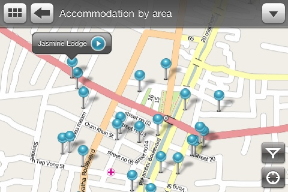
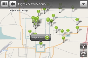
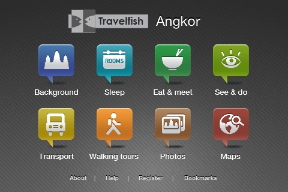
The main page has eight menu icons: Background, Sleep, Eat & meet, See & do, Transport, Walking tours, Photos, and Maps. Maps used throughout are based on the Open Street Map resource and not Google maps. This means that with data pre-loaded, roaming charges are reduced. Each map screen has two symbols: a locator and a link to settings, which allow the different pin types (green for food, yellow for transport). At the bottom there are also menu items, About, Help (to show how the app works), Register (news) and Bookmarks.
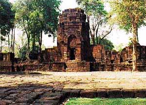
 As each icon is pressed, it is animated, appearing to rise slightly. The first, "Background", looks at the history of the monument and its surroundings. This, along with each section has several good photographs illustrating the text.
As I was testing the locator function in Bangkok, I was too far off the installed maps to show. It did try. This will be less effective on the iPod touch as locations depend on the user's proximity to antennas in the Skyhook database. There seems to be low coverage in Siem Reap. 3G and other phone access may also be limited there.
Each section also has its own index allowing quicker navigation through the app if a specific idea is wanted. On most pages at the top left are two small buttons: one to take the user back to the previous level and the other for returning to the top (index) page.
I travelled through Penang once when I had to leave my motorcycle in Kuala Lumpur and arrived there late at night. Although finding food is fairly easy in any city, accommodation needs some input. There are some 40 locations given here, and each is also shown on the useful map. The descriptions include links to email, websites and telephone numbers as well as to the map. There is also a review of each and these indicated how popularity has begun to affect prices. Clicking on the phone number of one guest house dialled it immediately so I would have preferred an option not to make the call which I later found with some airline phone numbers.
There are lots and lots of pins already placed on all the maps, but some are so close to each other that we have to use the "pinch" to enlarge the view. Like Google Maps, and Locations in iPhoto, touch a pin and brief details are shown; tap the arrow and a page opens.
The "Transport" section was interesting in the way practical experiences have been merged with bare facts, for example in the useful sections on border crossings: what you need and how long you may have to wait. 18 airlines are listed and each has a web link. Most also have phone numbers and when we click on these, the app offers to call the airline.
Each section has a good range of information with good illustrations making this a highly useful and practical use of up-to-date technology which may be of value to those travelling to Siem Reap and Angkor.
|